The problem with Karachi’s many master plans
In Pakistan, creating master plans has been static exercise every five or 10 years, with most master plans being out of date by the time they were published
June 11, 2018
From the year 1951 to 2006, in order to respond to the fast-changing social and economic scenario, the planners of Karachi proposed five master plans. (The sixth plan, dated till 2030, is in the offing). A master plan is a hefty document that shows how the community is at the moment and suggests how it should exist in the future.
Each plan took stock of the existing demand and supply of the various sectors, through investigation and research techniques.
One common string that cuts across the five plans was an emphasis on an institutional setup that would implement the recommendations. Yet, for one reason or another, the dream of implementation remained unfulfilled.
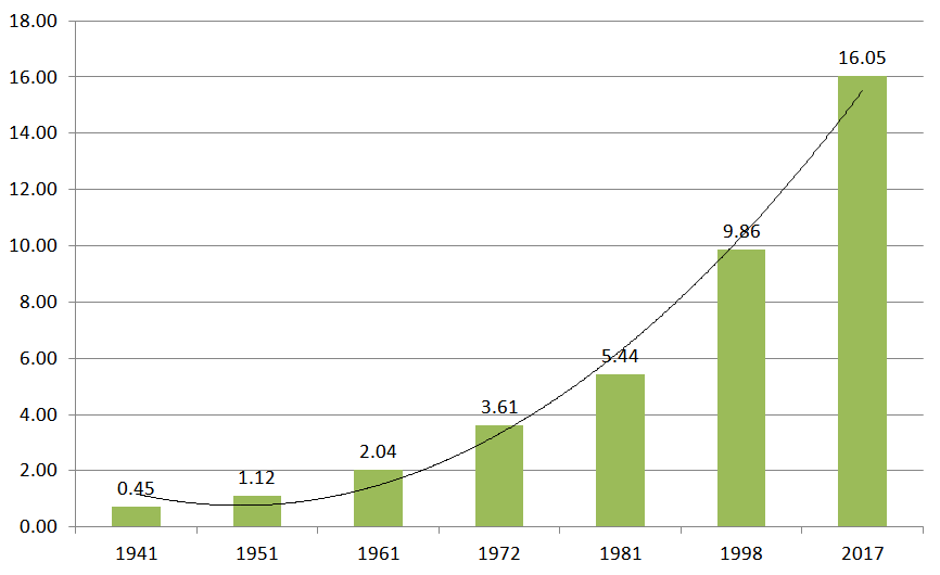
On the eve of partition, according to unofficial estimates, Karachi had a population of 700,000. With the advent of migrants from India, it rose to 1.12 million (census 1951). Though the 2017 population census puts the figure at over 16 million, researchers and demographers contest those figures and various media reports and documents claim, unofficially, that Karachi’s population is somewhere between 22 million to 25 million.
Regardless, of which figure you believe, since 1947 the city has grown 60 times its size. Karachi is the only city in the world that has experienced an unusual population growth from 0.71 million to 16.05 million in the last 70 years. This makes the job of the planners more complicated and difficult, due to the increase in demand for infrastructure and civic faculties.
The city has observed a phenomenon of spatial expansion along its three main highways: RCD, Super and National with more emphasis on the latter two. For any future planning, a spatial survey and satellite imagery would be needed. Spatial surveys are a method to document the built and natural environment for planning purposes.
With that in mind, the upcoming Master Plan 2030 will need to define the vision of the city. When the Karachi Strategic Development Plan 2020 was first presented in 2016, a lot of water has flown under the bridges of Karachi and those changes need to be understood and articulated for a better vision. But moving forward, a holistic vision should call for an integrated sectoral approach with pro-poor objectives. Hence the process for the preparation of the Master Plan 2030 should include, as a first step, a review and analysis of the existing conditions and secondly, it should bring out the multifaceted dimension of the prevailing urban crisis: namely, transport issues, housing deficit, the unabated growth of informal settlements, potable water management, collection of solid waste, unbridled commercialisation and commodification of land.
And yet at the same time due to factors (transport, livelihood opportunities and family transition to name only three) a lot of densification has taken place in the core of the city, which means that a renewed understanding of the environment would be required that defines residential, commercial and service areas clearly. For that, a random sample-based quantitative survey in diverse income group localities would help the planners to understand the changes that have occurred over the last 12 years.
As for transport, the Bus Rapid Transport System (BRTS), as envisaged in KSDP 2020, is not operational till now, and even if it was, it would only cater to 8 to 10 per cent of the total estimated commuting population of the city. Which is why the role of para-transport, as feeder buses, to the main BRTS, needs to be articulated in clear terms. In the same vein, the policy of signal-free corridors should be revisited as they have promoted the culture of over-speeding, a complete disregard to the physically challenged, aged and pregnant women and promote pompous elitism. The right to walk is nowhere on the agenda and the footpath and pedestrian bridges, due to technical and design reasons, are least supportive of the culture of walking.
A presentation of the proposed plan (for 2030) needs to be made to all stakeholders, inclusive but not limited to, the academia, the Karachi Metropolitan Corporation, the Karachi Development Authority, various land-owning agencies, provincial and national legislators, the governor of the province, utility agencies, various relevant associations and interest groups. Such consultation will help improve the final output.
Ideally, master plans are a technical response to the political and economic crises of capitalism in an urban environment. But in Pakistan, so far it has been a static exercise of creating a master plan every five or 10 years. With the exception of the KDP 1974-1985, most master plans were out of date by the time they were published.
Instead, the planning process needs to be autonomous and the execution of the plan to be free of political interference. It should be manned by well trained and well paid professionals. Finally, planners should be asking how do we make this possible? How do we implement this on the ground?
- Raza is a freelance researcher and a peripatetic with a special interest in demographic and societal changes in Pakistan. He can be reached at [email protected].


