The threat from glacial lake bursts
Local communities are more vulnerable to flood hazards as floods occur frequently due to global climate change in recent decades
May 19, 2022

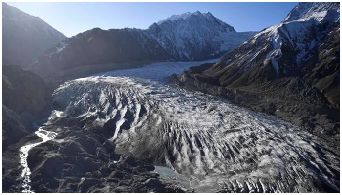
Since the early twentieth century, glaciers are on the retreat. Like the poles the Hindukush, Karakoram and Himalaya (HKH) region of Pakistan is also facing the effects of climate change in the form of the rapid melting of glacial ice mass, creation of new lakes and expansion of the existing ones which eventually result in glacial lake outburst floods (GLOFs) hazard downstream.
Recently, the Shisper glacier burst in Hunza valley which resulted in a flood and caused the Hussainabad bridge to collapse. GLOF often has catastrophic effects downstream but luckily there were no casualties this time.
Although exact knowledge about the glaciers and their behaviour is a must for disaster risk management and early warning, in the HKH region data collection is not easy and is hampered by highly inaccessible terrain and harsh climatic conditions.
As the glaciers retreat, glacial lakes start to form and rapidly fill up behind natural moraine or ice dams at the bottom or on top of these glaciers. As a result of climate change, glacial retreat is observed in most regions of the Hindukush Himalaya, which has given rise to the formation of numerous new glacial lakes.
According to Pak Met Department data, there are a total of 3,044 glacial lakes in the HKH region of Pakistan that covers a surface area of about 134.8 km. The four basins of the Karakoram Range – Gilgit, Hunza, Shigar and Shyok – contribute about 41% to the total lake numbers and lakes area. Out of 3,044 glacial lakes, 36 are classified as potentially dangerous glacial lakes in ten sub-basins of the Upper Indus Basin.
GLOFs are caused by the sudden bursting of the glacial lakes that are either ice-dammed or moraine-dammed which results in a catastrophic release of water. This is considered the most dangerous glacier-related hazard in terms of direct damage potential. The debris and rocks carried by the flood can devastate anything that comes in their flow path. It can destroy infrastructure and blast riverbanks and dams.
It is highly recommended that the identified dangerous glacial lakes especially those near the headwaters and settlements must be monitored regularly using high-quality remote sensing data combined with the field investigations. It is a must to install GLOF early warning systems all along the downstream.
Altogether, the Gilgit Basin possesses a higher lake area than the Indus Basin indicating the presence of large size lakes in the former basin. The largest lake of the Gilgit Basin has an area of about 2.71 km.
The local communities which have been experiencing flood hazards are now more vulnerable because of an increase in the frequency of these hazards due to global climate change in the recent decades. Already a series of GLOF events has occurred in recent years that has resulted in heavy damage to property and infrastructure besides loss of valuable lives in the HKH region of Pakistan.
The northern glaciated region has a population of about 0.5 million which is mainly concentrated in the main towns/villages in the valleys. Some of the villages are located in remote areas close to the snow and glacial cover that face the direct consequences of glacial hazards like outburst floods or surging.
There is an immediate need to raise public awareness of risks, strengthen communities’ preparedness and resilience and develop capacity-building plans for planners and local communities of remote mountain villages to cope with the high risk of GLOF hazards in this region.
Large flooding events can even impact communities of villages lying at far distances along the downstream areas. In most cases, village people living close or in the flow path of glaciers are under great mental stress because of the shadowing disasters and risks. Due to poor living conditions, lack of resources and proper management within the system the local communities have to face problems in taking effective response measures for risk reduction or mitigation.
Their agriculture and forest land irrigated through glacier melt is at risk. Main roads, highways and bridges that connect different towns and villages in the region are in danger. These have already been destroyed several times due to GLOF and landslide events in the past.
The most critical lakes in the region include Hunza, Gil-gl 621 lying over Sandhi and other villages in Yasin valley and Gil_gl 222 which can create frequent floods triggered by heavy rains affecting the downstream areas of Gakuch. Similarly, a hanging lake Gil_gl 595 in upper reaches of Dahimal can create an outburst flood hazard in case of any extreme rainfall/surging of its source glacier of hanging nature. The end-moraine dammed lakes Shyk_gl 265, Shyk_gl 262 in Shyok basins are found highly susceptible. Ast_gl 160 in the Astore basin and Ind_gl 148 in Indus sub-basin can create flood disastrous conditions for downstream communities in case of the rapid melting of their source glaciers.
The blocked lake Hunz_gl 13 created by a massive land sliding event at Attabad village in Hunza is highly susceptible to outburst flooding in case of any extensive breaching of the material under high pressure of upstream inflows. The supraglacial lakes Hunz_gl 14 over Ghulkin glacier in Hunza and Gil_gl 656 over Hinarchi glacier in Gilgit can also cause heavy damage.
It is highly recommended that the NDMA and the Ministry of Climate Change work together to reduce the risk of flood for the communities living in the wake of glacial floods. There is a need for early warning mechanisms including messaging service on mobile phones, alerts and alarms set in the identified areas, well-established temporary shelters for communities and livestock to relocate in case of flooding and ample resources for food and fresh water in stock.
It is not possible to prevent flooding from the bursting of a glacier; the only thing to be done is mitigation and saving the lives of people and livestock from damage caused by the flood. The time to act is now.
The writer is a freelance journalist.
Originally published in The News


