Florida to witness severe tornadoes, rains this weekend
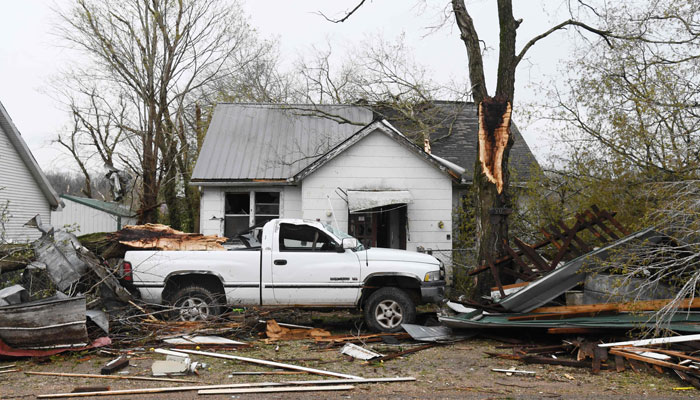
Thursday's disastrous tornadoes in Florida witnessed damages in more than a dozen counties
April 30, 2023

Just days after up to 40 severe storms and six were reported in Florida on Thursday, the National Weather Service has in an early warning said that the state should brace for another "round of severe storms and heavy rainfall", reported CNN on Sunday.
Saturday night also witnessed a strong tornado in Palm Beach Gardens, Florida where it was able to topple cars with debris turned up on the roads.
In a confirmation about the twister, the National Weather Service office in Miami said a survey of damage was underway.
The National Weather Service office in Tallahassee said: "Yet another round or two of severe weather and heavy rainfall is expected over the weekend," adding that "still some uncertainty in placement and timing, but the ceiling for this event may be a bit higher than Thursday's event."
In a tweet by the Palm Beach Gardens Police Department tweeted there was damage along a highway in the area and roads were blocked.
As a result of Thursday's disastrous tornadoes, Florida reported damages in more than a dozen counties including Liberty County, where a tornado tore the town of Hosford Thursday afternoon.
According to the storm prediction on Saturday, there is a Level 2 of 5 slight risks for severe storms for parts of the Florida Panhandle and southern Georgia, including Tallahassee and Panama City, Florida, and Valdosta, Georgia.
A marginal risk for severe storms spreads from southeastern Louisiana to coastal South Carolina down to central Florida, including New Orleans, Mobile, Tampa, Jacksonville, Orlando and Savannah.
The Storm Prediction Center also said: "Two rounds of strong to severe thunderstorms are expected across portions of Florida and southern Georgia this afternoon and overnight tonight with damaging winds, large hail, and a few tornadoes possible."
"More isolated severe storms are possible across parts of Mississippi and Alabama with an attendant damaging wind/hail threat."
Where rain is expected this week
Here is the prediction of rain for the next seven days. It means as Florida is already witnessing much rain, further precipitation could potentially cause flooding.
An excessive rainfall risk of levels 2 to 4 has been issued for some parts of Florida and Georgia, which state that the rains could exceed 3 inches.
For the area from coastal Mississippi over through coastal South Carolina, marginal risk level 1 has been issued.
Some parts are in dire need of rain
Some parts of Florida and Southern Georgia are having drought conditions which could end as a result of the rain.
However, the focus of the clouds will be across Tallahassee, Pensacola, and Panama City.
A drought monitor report noted that More than 65% of Florida is under drought conditions. Severe drought conditions exist across much of central Florida and include Tampa, Orlando, Daytona Beach, Gainesville, and Naples.
Across the state of Florida, more than 1300 acres of land suffered fires the past few weeks due to the drought.
Storms to shift east on Sunday
According to the weather forecast for Sunday, the potential for strong to severe thunderstorms would shift east and south. The areas that are at risk of tornadoes, hail, and severe winds are Dover, Delaware, down to Savannah, Georgia, as well as central and southern Florida.
The Miami weather service office noted: "The setup could potentially result in hazardous marine and beach conditions during the latter half of the upcoming weekend."
Though the good news is the affected areas of the Southeast would clear out by Monday with conditions returning to normal.


