Biparjoy makes landfall along India-Pakistan sea border
Complete evacuation of Keti Bandar and Zero Point in Badin has been implemented as a precautionary measure
June 16, 2023
- "Entire process of landfall is expected to take around six hours."
- 100,000 people evacuated from India's coastal areas amid cyclone.
- Biparjoy "slowed down", won't make landfall before nightfall in Pakistan.
The Pakistan Meteorological Department (PMD) said that Cyclone Biparjoy has made landfall along the Indian Gujarat coast near Jakhau port and the Pakistan-India border. Presently, the cyclone is approximately 130 kilometres away from Keti Bandar.
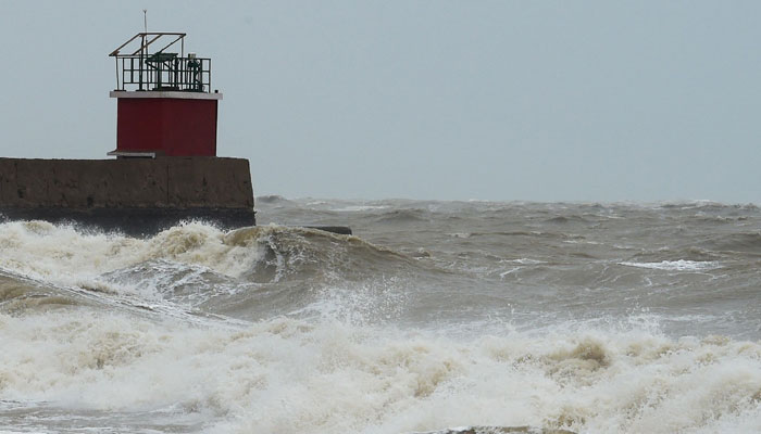
The coastal regions of Thatta are currently being ravaged by gale-force winds. In response to the imminent danger, authorities have taken decisive action, evacuating more than 78,000 individuals from areas deemed at high risk of impact. Notably, the complete evacuation of Keti Bandar and Zero Point in Badin has been implemented as a precautionary measure to safeguard lives and minimise potential damage.
After weeks of sweltering heat, the much-feared cyclone finally arrived, albeit with relatively limited impact. Karachi, Makli, Thatta, Badin and the coastal cities in its trajectory, received only light rainfall, effectively bringing an end to the prolonged period of intense heat.
As the cyclone's intensity significantly weakened, the anticipated heavy downpours failed to materialise. However, the gusts of winds provided a degree of relief to citizens weary of scorching temperatures. Initial concerns regarding severe weather conditions were alleviated as minimal rainfall was observed due to the cyclone's weakened state.
Looking ahead, the weather forecast for Sindh indicates pleasant conditions for today.
Cyclone Biparjoy, which made landfall in coastal areas of Gujarat, has seen a reduction in its intensity from the 'very severe' category to 'severe,' according to the India Meteorological Department (IMD). The cyclone has now moved from the sea to land and is centred towards Sauarashtra-Kutch, according to NDTV. Heavy rains are expected in Rajasthan today.
As a result of the cyclone, heavy rains and gusty winds with speeds exceeding 115–120 kilometres per hour caused significant damage in Gujarat's Morbi district.
Over 300 electric poles were damaged, leading to power outages in approximately 45 villages. Efforts are underway to restore power in nine of the affected villages, according to officials from the Paschim Gujarat Vij Company Limited (PGVCL).
Additionally, at least 22 people sustained injuries, and electric poles and trees were uprooted due to the cyclonic storm's impact. The cyclone is expected to weaken into a depression by this evening over Rajasthan.
AFP adds: Cyclone Biparjoy slammed into the Indian coast with powerful winds, sowing fear and prompting evacuations, but began weakening in the early hours of Friday as it moved north.
Indian forecasters had warned that Biparjoy, whose name means "disaster" in Bengali, was likely to devastate homes and tear down power lines as it barrels through the western state of Gujarat.
The "very severe cyclonic storm" crossed the coastline near Jakhau Port Thursday evening, but started losing force several hours later and at 2:30 am (2230 GMT) on Friday was packing 100 kilometres (62 miles) per hour winds with gusts up to 110 km/h, the Indian Meteorological Department (IMD) said in the latest bulletin.
"It would move northeastwards and weaken into a cyclonic storm by early morning of the 16th (of) June," the bulletin read.
Earlier, weather officials had said that the cyclone was expected to move overnight into Pakistan’s Sindh province, home to the port megacity of Karachi.
Jayantha Bhai, a 35-year-old shopkeeper in the Gujarat beach town of Mandvi, told AFP before the storm hit that he was afraid for his family’s safety.
"This is the first time I’ve experienced a cyclone," said Bhai, a father of three boys aged between eight and 15, who planned to wait out the cyclone in his small concrete home behind the shop.
"This is nature, we can’t fight with it," he said, as driving rain lashed his home.
Low-lying roads started to flood on Thursday afternoon after hours of rain.
Gusting winds blew sheets of water that reduced visibility with a dull grey mist.
Almost all stores were closed, and shoppers had crowded the few that remained open to buy last-minute food and water supplies.
India’s meteorologists warned of the potential for "widespread damage", including the destruction of crops, "bending or uprooting of power and communication poles" and disruption of railways and roads.
The Gujarat state government said 94,000 people had relocated from coastal and low-lying areas to shelter.
About 200 people huddled together in a single-storey health centre in Kutch district, a short distance from India’s Jakhau port, late on Wednesday.
Many were worried about their farm animals, which they had left behind.
Dhal Jetheeben Ladhaji, 40, a pharmacist at the health centre, said 10 men had stayed behind to look after hundreds of cattle crucial to their village’s livelihood.
"We are terrified, we don’t know what will happen next," Ladhaji said.
Cyclones -- the equivalent of hurricanes in the North Atlantic or typhoons in the Northwest Pacific -- are a regular and deadly menace on the coast of the northern Indian Ocean, where tens of millions of people live.
Scientists have warned that storms are becoming more powerful as the world gets warmer with climate change.
Nearly 100,000 people have been evacuated and moved to shelters ahead of the cyclone's landfall from Indian coastal areas.
The Indian authorities have also suspended commercial operations at Gujarat's Jamnagar airport till Friday.
‘Biparjoy slows down in Pakistan’
Meanwhile, according to Federal Minister for Climate Change Sherry Rehman, cyclone Biparjoy has "slowed down" and will not make landfall before nightfall in Pakistan.
Speaking during a press conference in the federal capital earlier today, the federal minister said it was previously expected that the cyclone would hit Sindh’s Keti Bandar around 11am.
“But, since the speed at which it is moving has slowed by 6-7km, its times of landfall is delayed and it is now expected to hit the shores until after dusk.”
However, the senator stressed that while the cyclone had "slowed down", its core was still "intense", and the areas identified earlier as vulnerable still needed to stay alert.
“We had earlier marked four districts at risk. Thatta, Badin, Sujawal and Malir (Karachi). Now, since the trajectory is towards the northeast, the Tharparkar region also needs to be aware of the impact of the cyclone,” she said.
“We will update you regularly since these storms are unpredictable,” Rehman said, adding that the storm was still heading towards the northeast.
She said that strong winds and heavy rainfalls are still expected to go up to 300mm in some areas, adding that while the cyclone had moved away from Karachi, its effects would be seen in these areas.
“A flood warning has been given in the sea,” she said. She warned that winds are blowing at a speed of 120-140km/h while waves of 30 feet and more are rising in the sea.
The Pakistan Meteorological Department (PMD) said maximum sustained surface winds are 120-140km per hour and gusts 150km per hour around the system center and sea conditions being rough/phenomenal around the system center with maximum wave height 25 feet.
Dust/thunderstorm-rain with few heavy falls and accompanied by squally winds of 60-80km per hour are likely in Karachi, Hyderabad, Tando Muhammad Khan, Tando Allayar, Shaheed Benazirabad and Sanghar districts on Thursday (today) and Friday.
Dust/thunderstorm-rain with isolated heavy falls likely in Hub, Lasbella and Khuzdar districts of Balochistan today and tomorrow (Friday). Strong winds may cause damage to loose and vulnerable structures (Kutcha houses) including solar panels etc.
Storm surge of three to four meters (10-13 feet) is expected at the land falling point Keti Bandar and around which can inundate the low-lying settlements.
Sea conditions along the Sindh coast may get very rough/ high (2-2.5 meters) and rough/ very rough (2 meters) along the Balochistan coast (Sonmiani, Hub, Kund Malir. Ormara and surroundings).
Sindh coastal areas feel impact of cyclone
Amid approaching cyclone Biparjoy, heavy to moderate rains were reported from various districts of Sindh including Badin, Thatta, Hyderabad, Mirpurkhas, Karachi and others.
Heavy rainfall accompanied with strong winds damaged several houses, electricity poles and trees in Badin district.
Electricity supply has also been suspended for last two days in fishermen's settlements along the coastline in the district while around 1,000 displaced fishermen are in relief camps in Badin.
Similarly, several parts of Karachi including Quaidabad, Malir, Gulshan-e-Iqbal, University Road and other areas received light to moderate rains.
Highest rainfall of 5mm was recorded in Quaidabad 5 mm followed by Jinnah Terminal 4.4mm at and 4.2mm University Road, the Met department said.
In Thatta district, local administration said army and civil agencies are jointly carrying out rescue and relief operations.
More than 80 thousand people were rescued from the coastal areas, the Thatta district administration said in a briefing.
Eleven relief and medical camps have been set up in Thatta district, Deputy Commissioner Ghulam Farooq Soomro said.
45 camps have been established in Badin, Thatta and surrounding areas where 34 thousand people are present, the deputy commissioner added.
He said food and other basic necessities including dry milk was being provided to the displaced persons in the camps.
In the next phase, he said the preparations to deal with the effects of the storm will be completed.


