Here's why Mount Everest 'is taller than it should be'
Scientists argue that river "capture" in Himalayas 89,000 years ago may be behind Everest's height
October 04, 2024
A new study suggests that an event of river “capture” in the Himalayas 89,000 years ago resulted in so much erosion eventually pushing the peak of Mount Everest up by 164 feet.
A river roughly 46 miles (75 kilometres) from Everest was "captured" by another around 89,000 years ago, according to a new study, reported Live Science.
The erosion caused by this event carved away a huge gorge. This led to a loss of landmass that made the mountain experience a major growth spurt.
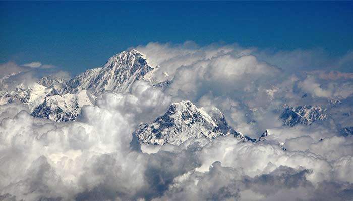
Notably, Mount Everest is Earth's highest peak on land at 29,031.69 feet (8,848.86m).
However, the study co-author Adam Smith, who is also a researcher at University College London’s Earth Sciences told Live Science that the mountain "is taller than it should be”.
The height difference between most mountain peaks in the Himalayas is about 164 to 328 feet (50m to 100m), however, Everest is 820 feet (250m), which is higher than the next highest mountain K2. "This perhaps hints that something interesting is going on," said Smith.
Moreover, GPS data shows Everest is growing at a rate of around 0.08 inches (2 millimetres) per year. This is higher than the expected rate of uplift for the mountain range.
In order to find out the root cause, the scientists looked at whether the Himalayas’ unusual rivers are behind this.
"The Arun River is weird, as it flows in an L shape," Smith said. "Most rivers resemble trees, with a relatively straight trunk, and branches (tributaries) flowing into the trunk. However, the Arun flows E-W [east to west] along its upstream portion, before turning 90 degrees and flowing south through the Himalayas. This hints that perhaps the river has recently changed its form, and has maybe 'captured' another river."
It was then suggested by the findings that the Arun River, which is now a main tributary of the Kosi River, was captured by Kosi around 89,000 years ago.
Consequently, this diverted river led to a surge in river erosion, carving out the Arun River Gorge.
Researchers argue that the creation of this gorge and erosion of the river would have removed enough landmass to make the surrounding land lighter, causing Everest to spring up. According to the models, since the capture event, the mountain has risen between 50 and 164 feet (15m to 50m).


